Mike's First Area: Palpalá
Palpalá was my first and only area
in the province of Jujuy
(pronounced hoo-HOO-e.) Jujuy is the most northeastern
province in
the country of Argentina, bordering on the countries of Chile and
Bolivia.
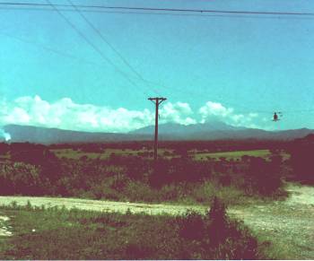 This
is a view of the surrounding region from the outskirts of
Palpalá.
Jujuy is a very dry, hot and desert area. Notice that the "street lamp"
dangling from power lines over the middle of this intersection consists
of little more than a 100 Watt bulb. Don't look for traffic
signals
to be found at these crossroads any time in the near future... This
is a view of the surrounding region from the outskirts of
Palpalá.
Jujuy is a very dry, hot and desert area. Notice that the "street lamp"
dangling from power lines over the middle of this intersection consists
of little more than a 100 Watt bulb. Don't look for traffic
signals
to be found at these crossroads any time in the near future... |
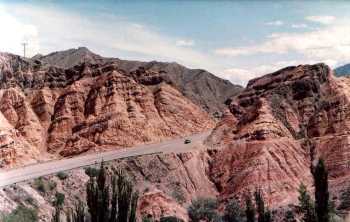 This
picture of Tilcara demonstrates the incredible heat and dryness that
scorches
hundreds of miles of Jujeño desert. The climate of
Jujuy is
attributed to two forces of nature: First, the Tropic of
Capricorn
slices straight through the middle of the province, thus allowing the
sun's
rays to scorch more directly on the land than in subtropical
regions.
Second, Jujuy is on the leeward side of the Andes,
the largest mountain range in the Western Hemisphere, preventing much
of
the moisture from reaching the parched earth. This
picture of Tilcara demonstrates the incredible heat and dryness that
scorches
hundreds of miles of Jujeño desert. The climate of
Jujuy is
attributed to two forces of nature: First, the Tropic of
Capricorn
slices straight through the middle of the province, thus allowing the
sun's
rays to scorch more directly on the land than in subtropical
regions.
Second, Jujuy is on the leeward side of the Andes,
the largest mountain range in the Western Hemisphere, preventing much
of
the moisture from reaching the parched earth.
|
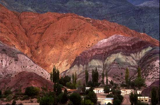 This
picture represents one of the most striking geological displays
encountered
on my mission... or anywhere else I've been for that matter.
This
is called the Hill of Seven Colors, near the Indian establishment
of
Humahuaca
(pronounced oo-ma-WA-ka.) Other impressive pictures of
Argentina,
including the Cataratas
de Iguazú--the body of water that makes Niagra
Falls look like
a leaky faucet--can be found here. This
picture represents one of the most striking geological displays
encountered
on my mission... or anywhere else I've been for that matter.
This
is called the Hill of Seven Colors, near the Indian establishment
of
Humahuaca
(pronounced oo-ma-WA-ka.) Other impressive pictures of
Argentina,
including the Cataratas
de Iguazú--the body of water that makes Niagra
Falls look like
a leaky faucet--can be found here.
|
|
Picture Pages:
|