Rocky
Canyon Geocaching

After a ward
campout near Idaho
City, we decided to take do some geocaching along a scenic
route home. We were favored with great weather and a list of
ten geocaches in
our GPS. We had our most productive
geocaching ever, having found nine caches in a single day.
And the tenth, we simply passed by because it was in a public
park, and didn't want to draw attention to the cache.
|
6/14/2008 Rocky Canyon, ID |
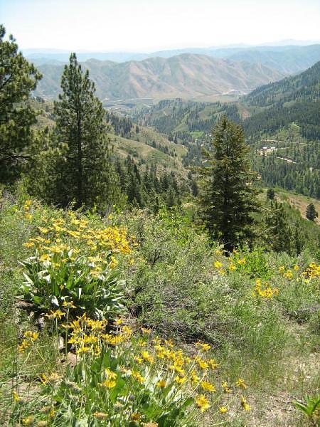 View from Boise Ridge looking towards Robie Creek and Lucky Peak State Park |
Geocaches Attempted
| "E" Gas | Found | |
| 'Snow Way Thru | Found | |
| Aldape Raptors | Found | |
| Dusty Rhodes | Found | |
| Grayback Gulch | Found | |
| James' Foothills Cache | Found | |
| Rocky Canyon 1 | Found | |
| Rocky Canyon Road cache | Found | |
| Rooney's Robie | Skipped | |
| Wrong Way to Robie Creek | Found |
GPS Info
We collected all of the following data from our GPS unit during the adventure:Maps
This Google Map is provided by GPS Visualizer
Elevation Profile
The elevation profile conveys three different main coloring schemes.- Blue/Purple: highway travel.
- Green/Yellow: dirt road travel
- Red/Orange: walking (while finding geocache... as you can tell, there were some calf-burning slopes to climb for some of these.)

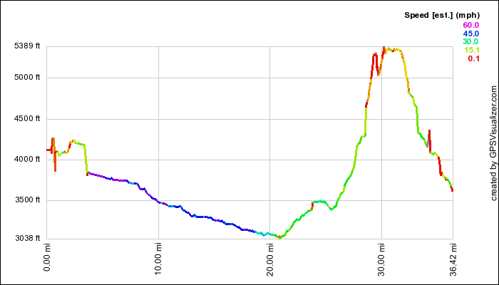
This profile s provided by GPS Visualizer
Coordinates and other details
|
36.4 Miles 4:16:26 9 MPH "Geocaches Attempted" links above contain coordinates, or GPX file below has waypoints to each cache. |
If you would like to use this info with your GPS unit, the full GPX file is here.
If you want to view this in Google Earth, you can download the KMZ files of the track and topographic overlay.