Eightmile
Creek Drive
This is a drive we'd have never found had it not been
for geocaching.
While exploring the history of the Yankee Fork area, we
thought we'd try to find some geocaches. While we never did
find this geocache, it took us along a fascinating road, high up the
windy Estes Mountain road, with sweeping views of the mountains and a huge open-pit
mine.
We couldn't reach the 9600-foot top of the mountain, where the
geocache was, because a large tree had not been cleared from the road
during the previous winter. We had to settle on 8400-foot views
of the surrounding area instead.
|
06/13/2007 Eightmile Creek |
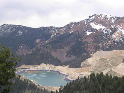 Now defunct, this is a picture of the cyanide lake at the site of the disappointing and devastating Grouse Creek open-pit gold mine operated by the Hecla Mining Company. (The interesting white- colored pattern on the lake is caused by sprinklers... we're guessing that these are used to help aeriate or dilute the toxic lake.) |
GPS Info
We collected all of the following data from our GPS unit during the adventure:Maps
This Google Map is provided by GPS Visualizer
Elevation Profile
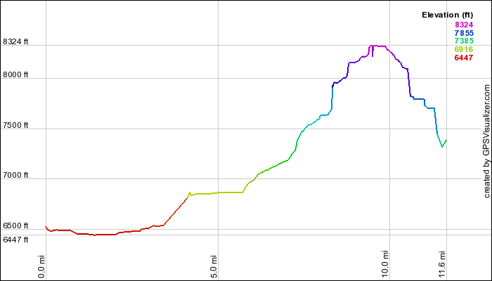
This profile is provided by GPS Visualizer
Coordinates and other details
|
11.7 Miles 01:01:04 11 Miles/Hr. N 44º 23.249, W 114º 41.799 N 44º 26.313, W 114º 42.590 |
If you would like to use this info with your GPS unit, the full GPX file is here.
If you want to view this in Google Earth, you can download the KMZ files of the track and topographic overlay.