|
7/5/13 - 7/6/13 Mt. Baker-Snoqualmie National Forest |
I counted 15 waterfalls coming off of this mountain cirque, each hundreds of feet tall. |

Report
We started out on the trail around 11:00am, and within the first mile, we bumped up against our first significant stream crossing. Sure, we could've easily forded this one, but that would mean getting wet, and none of us were wanting to take off our boots/socks this early in the trip, so we decided to use a log to cross. The next crossing went a lot smoother, since there was a carved out footbridge to use. That would be the last of the easy creek crossings. We would use more deadfall and test our ability to hop across slippery rocks more times than any of us care to remember. While the many crossings cost us plenty of time the first day, it was our inability to keep sight of the trail due to the many stream crossings and snow fields that really slowed our progress. We were lucky enough to have an angel hiker whose solitary pair of footprints we were able to make out at some of the snow fields. We felt triumphant with our navigational skills (or was it luck!) everytime we would locate his footprints, as a good indicator that we were on the right track. While our goal was Marmot Lake, we never made it! Instead, we were stopped less than one mile short of reaching the lake by a dangerous snow bridge over a 20-foot ravine. Instead, we had to back-track to a different camp site, where we finally pitched camp at 7:30pm near a cirque containing a glut of waterfalls. It may well have been a more beautiful setting than Marmot Lake anyway.
On day two, we woke up and decided to take the Pacific Crest Trail which took us up higher on a ridge (i.e. away from all of those pesky Deception Creek crossings). After rolling up camp and hitting the trail at 9:30am, we were treated to some wonderful panoramic scenery on the PCT, and because the trail was very well-established, we actually made better progress on the way back (1.6MPH average instead of 1.2MPH), even though the "scenic route" was longer, and we stopped for an hour-long picnic lunch and swim at beautiful Deception Lake. We made it back to the trailhead around 3:30pm exhausted, stiffened, but fulfilled. Everyone agreed that it was an awesome adventure worth the effort and pain! Of course, the stop at Zeke's drive-in on the way back home was the icing on the cake.
Photos
Here is an online album of photos. Unfortunately, I didn't realize that a fingerprint had smudged the lens, so the quality of the images is less than desirable this time.
GPS Info
Here is the GPS data collected during the trip:Maps
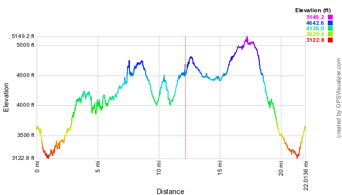
Elevation Profile
Coordinates and other details:
| Day One | Day Two | |
|
12.2 Miles 10:09:57 1.2 MPH 3474 Feet N47 39.185, W121 11.390 | 9.8 Miles 6:17:03 1.6 MPH 2331 Feet |
If you would like to use this info with your GPS unit, the full GPX file is here.
If you want to view this in Google Earth, you can download the KMZ files of the track and topographic overlay.